Code Monkey home page Code Monkey logo

osm-community-index's Introduction

build npm version

osm-community-index ("OCI")

💬 An index of community resources for OpenStreetMap.
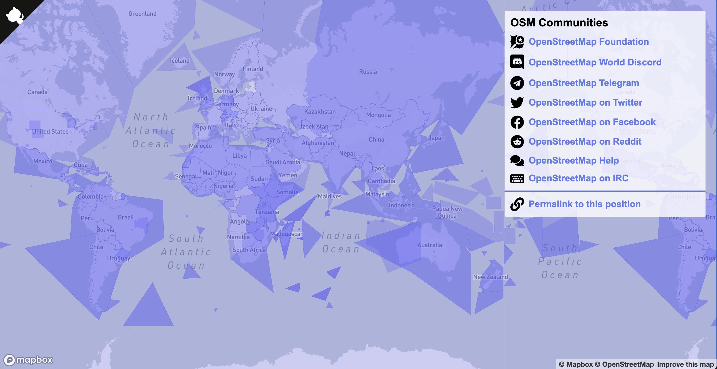
What is it?

This project is a list of resources for users of OpenStreetMap.

"Resources" can be links to forums, meetups, Slack groups, IRC channels, mailing lists, and so on. Anything that mappers, especially beginners, might find interesting or helpful.

Browse the index

openstreetmap.community

About the index

See the project wiki for details.

Participate!

We're always looking for help!

If you have any questions or want to reach out to a maintainer, ping @bhousel or @aawiseman on:

License

osm-community-index is available under the ISC License. See the LICENSE.md file for more details.

This project also bundles some icons from FontAwesome. The icons are licensed CC BY 4.0 (https://creativecommons.org/licenses/by/4.0/).

osm-community-index's People

Contributors

1ec5 avatar aawiseman avatar andygol avatar attilakundev avatar bezdna avatar bhousel avatar danieldegroot2 avatar demonshreder avatar dependabot[bot] avatar govvin avatar gplv2 avatar greenkeeper[bot] avatar hbogner avatar hikemaniac avatar holgerjeromin avatar iandees avatar ignaciolep avatar javiersanp avatar jbelien avatar jmaspons avatar joostschouppe avatar kmpoppe avatar matkoniecz avatar naveenpf avatar quincylvania avatar sk53 avatar stefanb avatar supaplextw avatar tyrasd avatar undearius avatar

Stargazers

 avatar  avatar  avatar  avatar  avatar  avatar  avatar  avatar  avatar  avatar  avatar  avatar  avatar  avatar  avatar  avatar  avatar  avatar  avatar  avatar  avatar  avatar  avatar  avatar  avatar  avatar  avatar  avatar  avatar  avatar  avatar  avatar  avatar  avatar  avatar  avatar  avatar  avatar  avatar  avatar  avatar  avatar  avatar  avatar  avatar  avatar  avatar  avatar  avatar  avatar  avatar  avatar  avatar  avatar  avatar  avatar  avatar  avatar  avatar  avatar  avatar  avatar  avatar  avatar  avatar  avatar  avatar  avatar  avatar  avatar  avatar  avatar  avatar  avatar  avatar  avatar  avatar  avatar  avatar  avatar  avatar  avatar  avatar  avatar  avatar  avatar  avatar  avatar  avatar  avatar  avatar  avatar  avatar  avatar  avatar  avatar  avatar  avatar  avatar  avatar

Watchers

 avatar  avatar  avatar  avatar  avatar  avatar  avatar  avatar  avatar  avatar  avatar  avatar  avatar  avatar  avatar  avatar  avatar  avatar  avatar  avatar  avatar  avatar  avatar  avatar  avatar  avatar  avatar  avatar  avatar  avatar  avatar

osm-community-index's Issues

Oceania region

Should we change Australia to Oceania?
This will be more welcoming for Fiji, New Zealand, Papua New Guinea etc.

Also our regional SotM is going by this name.

What are "types"

Each resource has a "type" property..

{
    "type": "Feature",
    "properties": {
        "id": "OSM-US-Slack",
        "type": "slack",
        "country_code": "US",
        "name": "OpenStreetMap US Slack",
        "description": "Sign up at {url}",
        "url": "https://osmus-slack.herokuapp.com/"
    },
    "geometry": { 
        ...
    }

I left this a free-text property. But we might want to have a list of acceptable types.

Community resource name

Community Resource Name

What is it?

URL link to the resource

Points of contact

Bounding polygon

Description (optional)

Languages spoken (optional)

Country codes (optional)

Add an emoji flag (optional)

Don't check in built files on master

I'm going to switch this repo over to how we do things in the iD project, where we separate master branch without built files, and a release branch that has the built files (and where we do git tag and npm publish).

What is a 'local' user?

Trying to understand the scope. Everyone using OSM is a 'local' user. Is this supposed to explicitly exclude "global" resources like the OSM wiki, global mailing lists etc?

Happy to work on the README as this becomes clearer to me.

Add icons

Following up from #1 (comment)
I'm going to add a nice icon for each of the resource types we support, and drop them into dist somehow automatically.

Drop precision of geojson files

The build script does some automatic processing of the geojson files already to:

  • enforce right-hand winding order
  • prettify the output

We should also drop the double precision coordinates within the files to make them smaller. 5 decimal places equals about 1 meter resolution at the equator, and is good enough for the purposes of this index.

Most of the files are already pretty small, but this could help shrink germany.geojson and belgium.geojson a lot more.

Push only global ressources to transifex for translation

From https://github.com/osmlab/osm-community-index/blob/master/CONTRIBUTING.md :

All community resources automatically support localization of the name, description, and extendedDescription text. These fields should be written in US English.

Please push only global ressources to transifex to translate to all languages.
Other resources should not be pushed to transifex but translated by the local community.
It is not helpfull to translate community contact information to languages not spoken by the local community. I try to keep the German iD-Translation up to date and i would prefer to see "0 strings to translate" even if strings like "OSM Chattanooga" (Tennesee, less then 200k people) is not translated.

Just make this Python already

Does anyone have any serious objections if I replace the (very few) Javascript scripts in this repository with Python? It would make things so much easier with testing, publishing, dependency management, etc?

Python ate the osm world already, lets just use it. This whole repo is JSON files anyway.

(See also: osmlab/editor-layer-index#168) 😜

osm-bolivia

Community Resource Name

"OpenStreetMap Bolivia"

What is it?

"mailing list"

URL link to the resource

Mailing list: https://lists.openstreetmap.org/pipermail/talk-bo

Points of contact

name: "Marco Antonio", email: "[email protected]"

Bounding polygon

relation: https://www.openstreetmap.org/relation/252645

Description (optional)

description: "Talk-bo is the official mailing list for the Bolivian OpenStreetMap community"

extendedDescription: 'Mapping in Bolivia? Have questions, want to connect with the community here? Join us at {Url}. All are welcome!'

Languages spoken (optional)

"es"

Country codes (optional)

"bo"

OpenStreetMap Chile

OpenStreetMap Chile

Description in spanish for the current four channels (Facebook, Mailing List, Telegram and Twitter in that order)

"description": "Únete a la comunidad de OpenStreetMap Chile en Facebook",
"extendedDescription": "Únete a la comunidad para aprender más sobre OpenStreetMap, realizar preguntas o participar en nuestras reuniones ¡Todos son bienvenidos!",

"description": "Una lista de correos para discutir sobre OpenStreetMap en Chile"

"description": "Únete a la comunidad de OpenStreetMap Chile en Telegram",
"extendedDescription": "Únete a la comunidad para aprender más sobre OpenStreetMap, hacer preguntas o participar en nuestras reuniones ¡Todos son bienvenidos!"

"description": "Síguenos en Twitter en {url}"

cl

Openstreetmap

Community Resource Name

What is it?

URL link to the resource

Points of contact

Bounding polygon

Description (optional)

Languages spoken (optional)

Country codes (optional)

Add an emoji flag (optional)

Integrate User groups in Wiki via UserGroupsBot

See wiki page: https://wiki.openstreetmap.org/wiki/User:UserGroupsBot

A bot automatically creates a kml resource based on User Groups maintained on the Wiki. Essentially this means that everyone is free to add local user group meetings in the Wiki without creating some pull request here.

Results are shown e.g. on different specialized maps, such as https://www.openstreetmap.de/karte.html, see the small icons on the "Lokale Gruppen" (local group) overlay.

Edit: ah, something similar was already discussed before in another repo: osmlab/osm-planning#5 (comment). Everyone maintaining their own list is probably creating extra effort, so leveraging what is already available as much as possible would be a plus.

BTW: https://xkcd.com/927/ anyone? 😎

Add upcoming events?

Some groups will have events (like local State of the Map conference, meetups, etc).
Should we add an upcoming events data to this index so that tools like iD can show the user when the group's next event will be?

OpenStreetMap Sweden 🇸🇪

Community Resource Name

OpenStreetMap Sweden

What is it?

  • Homepage
  • Mail list
  • IRC
  • Taginfo
  • Task manager
  • Facebook
  • Twitter

URL link to the resource

URL links to the resources

Points of contact

@magol

Bounding polygon

https://gist.github.com/magol/3fea83f0ae940a6069c442f10206e50e

Description (optional)

Languages spoken (optional)

sv

Country codes (optional)

se

Add an emoji flag (optional)

🇸🇪

Add OpenstreetMap users:Austria Forum Link 🇦🇹

Community Resource Name

"OpenStreetMap Austria Forum"

What is it?

Its a Forum

URL link to the resource

https://forum.openstreetmap.org/viewforum.php?id=89

Points of contact

emga, [email protected]

Bounding polygon

Description (optional)

Das offizielle Forum zu OpenstreetMap Fragen rund um und in Österreich
The official forum to OPenstreetMap questions in and around Austria

Languages spoken (optional)

en, de

Country codes (optional)

AT

Add an emoji flag (optional)

🇦🇹

OSM Peru 🇵🇪

Community Resource Name

Openstreetmap Peru

What is it?

  • Homepage
  • Mail list
  • Matrix
  • Telegram
  • Twitter
  • Facebook

URL link to the resource

URL links to the resources

Points of contact

@osm-pe Team on GIthub
https://wiki.openstreetmap.org/wiki/ES:Per%C3%BA OSM Wiki

Bounding polygon

Description (optional)

Languages spoken (optional)

"es"

Country codes (optional)

"pe"

Add an emoji flag (optional)

🇵🇪

Let's talk about `description`

The example community resource has this:

{
  "id": "OSM-US-Slack",
  "name": "OpenStreetMap US Slack",
  "description": "Sign up at {url}",
  "url": "https://osmus-slack.herokuapp.com/",
  ...
}

That description is not great. It's really just a placeholder.
Using my iD mockup below for inspiration - what kinds of things do we want to include in a description?

  • How long is reasonable? A few lines?
  • Formatting? We could do markdown, but I'd rather not.
  • I put that {url} token in there, thinking we might replace it with the real url, but then we also need url text. Thinking about it more, I'd prefer not to do token replacements unless we have a compelling reason.
  • That url link goes to the auto-inviter, not to the actual url which is https://osmus.slack.com - is that weird? (maybe need separate signup and visit links?)
  • Should we add another field for a more extended description, maybe more suited for an expandable block of text, like these "details" things:
    lots of good stuff in here

screenshot 2018-03-13 12 57 45

linkify reddit

After my change I got

/r/openstreetmap/ is a great place to learn more about OpenStreetMap. Ask us anything!

message. I think that "/r/openstreetmap/" should be a link leading to this community

Use Travis + the Meetup API to populate upcomming events

From the comment #63 (comment) it sounds like having the extra metadata will show the actual meetup events.

Looking at the Meetup API https://www.meetup.com/meetup_api/docs/find/upcoming_events/ it seems like that meeting info could be periodically scraped. EX: https://api.meetup.com/open-cleveland/events?&sign=true&photo-host=public&page=5&status=upcoming

You might be able to use the Travis CI cron jobs to do this periodically https://docs.travis-ci.com/user/cron-jobs/

adding an additional type

Can type be expanded to the non-commercial equivalent of slack ? aka, matrix / riot .

It would probably be better to make it a more generic description like 'webchat' instead of brand names unless it's deliberately used like that somewhere for a reason I'm not aware of.

Community microservice

We could experiment putting this community index behind a simple microservice so that any requestor can ask "what are the communities around this lat/long point" and get back an answer.

I've been wanting to play around with up for a while and that might be a fun use of the technology. (It's free up until we hit 1 million requests per month).

cc @mikelmaron

Add guide for adding resources

I would like to add two resources for Styria which is a part of Austria which is in Europe. It would help much if I can see in Readme.md how to do that. Do I have to create a folder styria inside the folder at inside Europe? Where do I put the geojson-files etc.

Translations

It's already set up to create a source strings a file for Transifex. I just need to add a project for it and type up docs.

Split up data and polygons

Before we go too wild adding all the things, we should separate the data from the polygons so that we don't run in to the kind of geojson duplication we see in editor-layer-index.

Region based wiki top level pages are valid 'community' aspects

(Example): Wisconsin Wiki mapping practices and ongoing projects (if you don't want to do this state-by-state, perhaps at least the national level Wikiproject page could be linked to: https://wiki.openstreetmap.org/wiki/Wisconsin

Community Resource Name

Wiki suggested mapping guidelines and regional projects

What is it?

Wiki page (and probably 'some' regional Wiki page exists for most places for which an OSM community does - this is particularly true in the US

URL link to the resource

https://wiki.openstreetmap.org/wiki/Wisconsin

Points of contact

If someone edits the Wiki and the page is watched, affected parties will be notified through the Wiki system

Bounding polygon

Description (optional)

Lists projects and suggested standards used to map the state of Wisconsin.

Languages spoken (optional)

en

Country codes (optional)

us

Add an emoji flag (optional)

us

Recommend Projects

  • React photo React

    A declarative, efficient, and flexible JavaScript library for building user interfaces.

  • Vue.js photo Vue.js

    🖖 Vue.js is a progressive, incrementally-adoptable JavaScript framework for building UI on the web.

  • Typescript photo Typescript

    TypeScript is a superset of JavaScript that compiles to clean JavaScript output.

  • TensorFlow photo TensorFlow

    An Open Source Machine Learning Framework for Everyone

  • Django photo Django

    The Web framework for perfectionists with deadlines.

  • D3 photo D3

    Bring data to life with SVG, Canvas and HTML. 📊📈🎉

Recommend Topics

  • javascript

    JavaScript (JS) is a lightweight interpreted programming language with first-class functions.

  • web

    Some thing interesting about web. New door for the world.

  • server

    A server is a program made to process requests and deliver data to clients.

  • Machine learning

    Machine learning is a way of modeling and interpreting data that allows a piece of software to respond intelligently.

  • Game

    Some thing interesting about game, make everyone happy.

Recommend Org

  • Facebook photo Facebook

    We are working to build community through open source technology. NB: members must have two-factor auth.

  • Microsoft photo Microsoft

    Open source projects and samples from Microsoft.

  • Google photo Google

    Google ❤️ Open Source for everyone.

  • D3 photo D3

    Data-Driven Documents codes.