roblabs / gdal-geopdf Goto Github PK
View Code? Open in Web Editor NEWProcessing GeoPDFs using GDAL
License: MIT License
Processing GeoPDFs using GDAL
License: MIT License


How to convert the El Capitan GeoTIFF to California Albers
# Get the Forest Service GeoTIFF for El Capitan
wget https://data.fs.usda.gov/geodata/rastergateway/data/37119/fstopo/373711937_El_Capitan_FSTopo.tif
# epsg.io/4269
gdalinfo 373711937_El_Capitan_FSTopo.tif | grep AUTHORITY


# Convert using GDAL to epsg.io/3310
gdalwarp -t_srs EPSG:3310 373711937_El_Capitan_FSTopo.tif el-cap.3310.tif
While downloading National Forest System Trails from FSTopo, some of the Pacific Crest Trail is missing in certain National Forests.
FSTopo Transportation Line and have FCSUBTYPE of 106, 107 and 525. See #1 for details.FSTopo Transportation LineS_USA.FSTopo_Transport_LN in redS_USA.TrailNFS_Publish in black with no shape file nor trail data
GeoPDF and Vector Shape file data for 7.5' Palomar Observatory quad show there are differences between the USGS and USFS topo maps.
Filing this issue as a tracking issue to share with others who may be using the US Topo PDF, FSTopo PDF and FSTopo vector data.
See live map at RobLabs.com/usgs
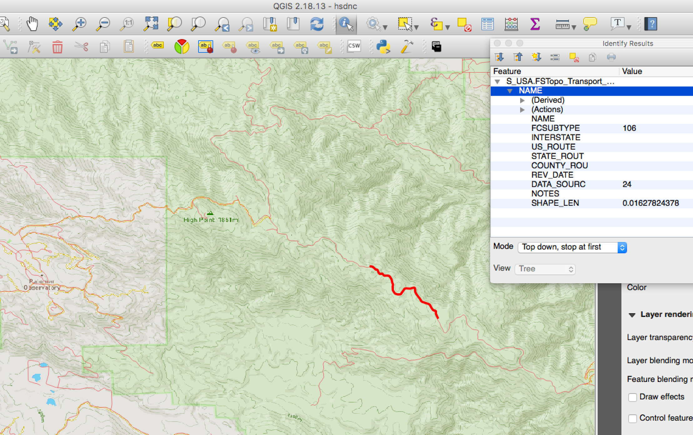
FCSUBTYPE? An issue filed by JesseCrocker suggests that FCSUBTYPE = 107 & FCSUBTYPE = 525 are significant: trailbehind/USFSTrailImport#1FSTopo Transportation Line (Date of last refresh: Oct 25, 2017) shows the Barker Valley trail labeled as FCSUBTYPE = 107FSTopo Transportation Line SourceFSTopo Transportation Line, FCSUBTYPE = 107
FSTopo Transportation Line, FCSUBTYPE = 106Barker Valley trail is just below this highlighted section of the Palomar Divide Road.
PALOMAR OBSERVATORY, CAwget https://data.fs.usda.gov/geodata/rastergateway/data/33116/fstopo/331511645_Palomar_Observatory_FSTopo.pdf
PALOMAR OBSERVATORY, CAwget https://prd-tnm.s3.amazonaws.com/StagedProducts/Maps/USTopo/1/22340/7541782.pdf
When processing the 2018 Geospatial PDFs from the nationalMap.gov an error occurs that was not seen when processing the same quadrangle from 2015. Posting this issue in case someone else has any research into what the problem may be.
gdal_translateERROR 1: insufficient arguments for Marked Content# wget
wget
https://prd-tnm.s3.amazonaws.com/StagedProducts/Maps/USTopo/PDF/CA/CA_Descanso_20150223_TM_geo.pdf
#gdal
gdal_translate CA_Descanso_20150223_TM_geo.pdf CA_Descanso_20150223_TM_geo.tif -co COMPRESS=LZW --config GDAL_PDF_DPI 200
# wget
wget
https://prd-tnm.s3.amazonaws.com/StagedProducts/Maps/USTopo/PDF/CA/CA_Descanso_20180904_TM_geo.pdf

#gdal
gdal_translate CA_Descanso_20180904_TM_geo.pdf CA_Descanso_20180904_TM_geo.tif -co COMPRESS=LZW --config GDAL_PDF_DPI 200

# Errors many times; similar to this
ERROR 1: Pos = 47918296, insufficient arguments for Marked Content
ERROR 1: Pos = 47918296, insufficient arguments for Marked Content
ERROR 1: Pos = 47918317, insufficient arguments for Marked Content
ERROR 1: Pos = 47918327, insufficient arguments for Marked Content
ERROR 1: Pos = 47918327, insufficient arguments for Marked Content
ERROR 1: Pos = 47918329, insufficient arguments for Marked Content
ERROR 1: Pos = 47918334, insufficient arguments for Marked Content
ERROR 1: Pos = 47918334, insufficient arguments for Marked Content
ERROR 1: Pos = 47918334, insufficient arguments for Marked Content
ERROR 1: Pos = 47918339, insufficient arguments for Marked Content
ERROR 1: Pos = 47918343, insufficient arguments for Marked Content
ERROR 1: Pos = 47920226, insufficient arguments for Marked Content
ERROR 1: Pos = 47920231, insufficient arguments for Marked Content
ERROR 1: Pos = 47920268, insufficient arguments for Marked Content
ERROR 1: Pos = 47920268, insufficient arguments for Marked Content
ERROR 1: Pos = 47920271, insufficient arguments for Marked Content
ERROR 1: Pos = 47946009, insufficient arguments for Marked Content
ERROR 1: Pos = 47946015, insufficient arguments for Marked Content
ERROR 1: Pos = 47947917, insufficient arguments for Marked Content
ERROR 1: Pos = 47954326, insufficient arguments for Marked Content
A declarative, efficient, and flexible JavaScript library for building user interfaces.
🖖 Vue.js is a progressive, incrementally-adoptable JavaScript framework for building UI on the web.
TypeScript is a superset of JavaScript that compiles to clean JavaScript output.
An Open Source Machine Learning Framework for Everyone
The Web framework for perfectionists with deadlines.
A PHP framework for web artisans
Bring data to life with SVG, Canvas and HTML. 📊📈🎉
JavaScript (JS) is a lightweight interpreted programming language with first-class functions.
Some thing interesting about web. New door for the world.
A server is a program made to process requests and deliver data to clients.
Machine learning is a way of modeling and interpreting data that allows a piece of software to respond intelligently.
Some thing interesting about visualization, use data art
Some thing interesting about game, make everyone happy.
We are working to build community through open source technology. NB: members must have two-factor auth.
Open source projects and samples from Microsoft.
Google ❤️ Open Source for everyone.
Alibaba Open Source for everyone
Data-Driven Documents codes.
China tencent open source team.